Travel Reference
In-Depth Information
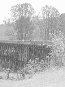
er. After going through dense trees, you will emerge to glide over bridges high above
Laurel and Green Cove creeks.
Intricate trestle bridges help make this one of Virginia's rail-trail gems.
At approximately the midpoint of the Creeper, you will reach the Damascus trail-
head. Before tackling the rest of the trail, consider taking a break in this sweet town.
Damascus is the self-proclaimed friendliest town on the trail, and it won't take you
long to see why: Its trailhead offers restrooms, a caboose-turned-information-booth, a
replica train engine, and parking. Veer off the trail to find lunch stops and bike shops
in town.
After your break, get ready for a little work: From Damascus to the trail's end
in Abingdon, a little more effort is required. The constant downhill is exchanged for
a flat grade with some gentle rises and descents. It's not strenuous, but it is a change
from the first section of trail. If you are bicycling, be aware that abundant equestrian
use just after Damascus can leave its mark on the trail surface and give you a bumpy
ride. But don't let a few bumps get you down. They start to peter out about 7 miles
before Abingdon, and some of the Creeper's most beautiful river and farmland views
are still ahead.
On a ridgeline high above the South Fork Holston River, you will emerge onto
a bridge offering invigorating views of South Holston Lake about 1770 feet below.
Enjoy the water, cliffs, and trees while they last, because the landscape is about to
change again, this time to peaceful, sprawling ranchland.
As you continue your journey toward Abingdon you will run into cattle gates
across the trail. These gates mark your entrance to the Creeper's expansive grazing
meadows. This tranquil farmland accompanies you for much of the remainder of the