Database Reference
In-Depth Information
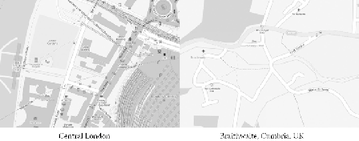
FIGURE 3.12
OpenStreetMap: London and Braithwaite in England. (© OpenStreetMap
contributors, CC BY-SA.
http://www.openstreetmap.org/copyright
)
there is one shared expectation: that all this data is free and is available to be shared
and recombined with other data. Indeed, this is the guiding principle on which
Wikipedia, GeoNames, and OpenStreetMap were founded.
The creation of such datasets is not without issues. Collection can be very biased,
both socially and geographically. Not only are contributors typically middle-class
and male, but also strong evidence exists that the majority of work is conducted by
a minority of the membership. Geograph (
http://www.geograph.co.uk
)
is a Web site
that allows contributors to send in a photograph of a landscape with the intention of
providing at least one photograph for each square kilometer of the United Kingdom.
Based on data for 2008 obtained from Geograph, the authors noted that at that time
1,738,728 photographs had been submitted by 9746 contributors, but that the top
20 contributors had submitted 25% of all the photos, and the top 100 had submit-
ted 50%. Similarly, in analysis of tagging of OpenStreetMap for England, of the
3332 unique editors, 231 contributed 71% of all edits, and 39 “superusers” contrib-
uted 39% (Mooney and Corcoran, 2011). This is not atypical for crowd-sourced data.
Furthermore, contributions are normally skewed heavily in favor of urban areas
(although not so much for Geograph); contrast OpenStreetMap for London and that
of Braithwaite (a much more rural location) in Figure 3.12.
The content can also vary significantly in detail depending on who collected it.
And, there are questions over the longer-term sustainability of these projects: People
to tend to like to fill blank canvasses rather than update what is already there; what
happens when the next cool thing comes along? But nonetheless, we should not
underestimate the achievements of these initiatives; if nothing else, they indicate the
willingness of many members of the public to contribute in this way and on many
different topic areas, not just geography. It also shows that there is a need for GI to
make a lot of these applications work, whether GI is at the center or not.
3.5.2.1 Open Government Data
Last, turning to the government sphere, recent trends have led to the freeing of
much government data, especially in the United States and United Kingdom. In the
United States, where federal data is already available on request, the challenge has