Geography Reference
In-Depth Information
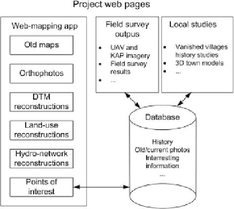
Fig. 3 The information
system structure
The
basemap layers
(old maps, orthophotos) are published as tiled (cached)
services allowing faster data viewing by the end users. The
operational layers
(vector layers, DTMs) are published as dynamic layers so they are easily
transformed into another coordinate system within a desktop GIS. All the published
data are protected, so the user is allowed to view, query or print the data, but not to
save them to a hard drive. This allows the user to work with a variety of
processed maps.
The web mapping application offers the user to view and visually analyze all the
processed data. Different types of processed data are currently available for each of
the sites of interest as different methodologies for data processing were tested.
A comprehensive webpage is under preparation and thus there are currently several
isolated web-applications covering all the sites of interest.
The applications are built using the ArcGIS API for Flex and are based on the
ArcGIS Viewer for Flex. This technology is very flexible and presents the data in a
very effective and feasible way.
Within the web mapping application the user can view the processed maps as the
base layers, switch between them and change their transparency. This allows the
user to visually compare the presented base maps. Other tools available are
implemented for visually comparing the data—for example a swipe tool or a
“magnifying glass”. The user is allowed to export the currently viewed data to
different graphic formats.
The user is offered different types of
operational layers
for each of the sites.
Within these layers we can encounter hydrology network reconstructions, digital
terrain models and their analysis, land-use interpretations, data obtained from local
surveys (KAP, UAV) and other data extracted from old maps and aerial imagery.