Geography Reference
In-Depth Information
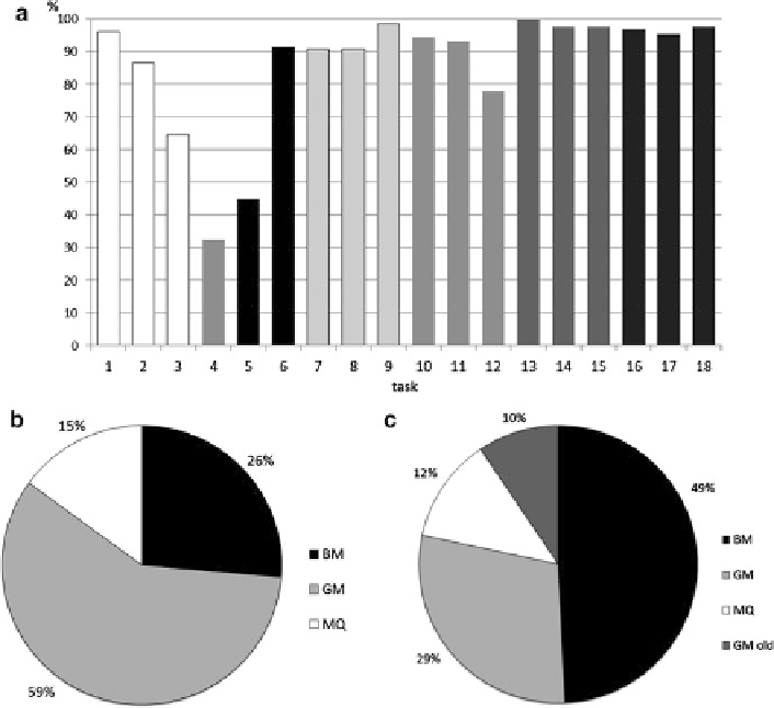
Fig. 3 (a) Correctness rate for the test tasks:
1
-
3
bodies of water on MQ,
4
-public buildings on
BM,
5
,
6
-labels on BM,
7
-
9
post offices on BM, GM, MQ,
10
-
12
pharmacies on BM, GM, MQ,
13
-
15
parks on BM, GM, MQ,
16
-
18
intersection of river and railway on MQ, BM, GM; (b)
Preferences of tested portals regarding visualization; (c) symbology preferences
water (they actually represent the interior structure of public buildings) (see Figs.
1
and
3
, task 4). The legibility of map labels for large cities on BM was examined in
the same way—the users chose the name of the largest city on the map by clicking
on an appropriate button (Fig.
3
, tasks 5 and 6).
The task in the third portion of the test involved marking an appropriate point by
clicking on the map field. Only one point on the map could be marked. The purpose
of this portion was to evaluate the distinctiveness of symbols and users
efficiency
when orienting themselves on a map. The respondents were asked to find the
nearest post office to a given street intersection (Fig.
3
, tasks 7-9), the nearest
pharmacy to a given hotel (Fig.
3
, tasks 10-12) and parks (Fig.
3
, tasks 13-15) on
all three examined map portals. The final task was to mark the intersection of a
watercourse and a railway (Fig.
3
, tasks 16-18). This set of tasks used similar map
segments to ensure the comparability of all three evaluated map portals. Selected
'