Geography Reference
In-Depth Information
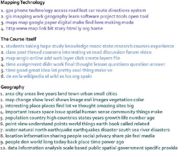
Fig. 3 Major topics uncovered from discussion forum posts using MALLET
the Maps MOOC. Input data for TMT was comprised of the text from 95,958
discussion forum posts created by students in the class.
Figure
3
shows an overview of the top 20 topics identified by MALLET from our
discussion post dataset. We have further categorized the top 20 topics into three key
themes that appear to link individual topics; Mapping Technology, the Course
Itself, and Geography. Students frequently discussed the impact of mapping and
location technology, with a specific interest on changes in the ways maps are made
today. One topic shows artifacts of a very common URL shortening service, which
was widely used by students who shared the web maps they created with one
another.
The second major category of topics concerns the course itself. Students fre-
quently talked about class policies, their goals for taking the MOOC, and aspects of
assignments that they struggled to complete or understand. One outlier here is the
final listed topic in this category which shows several Spanish words and references
a wiki. A large group of Spanish-speaking students took this course, and the
Spanish-speaking study group thread in the study group forum was among the
most active of all study groups. Students in that thread and others frequently posted
links to Wikipedia articles in Spanish to help elaborate concepts from the lectures in
the course.
Finally, the largest category of topics concerns Geographically-focused discus-
sions. Students talked about the discoveries they made about populations, land
cover change, hazard analysis, and social media—all of which were key themes in