Environmental Engineering Reference
In-Depth Information
onmental factor determines a spatial gradient, this leads
to the development of
zonation
, perpendicular to this
factor. Typical examples include altitudinal gradients
in mountainous areas and hydrological gradients in
river valleys (Fig. 3.7), but also gradients in land-
use intensity in the past. Even in cases where more
major factors determine species patterns one can often
witness a relatively simple zonation, because the fac-
tors often coincide to a high degree in the gradient.
Until recently, land use was highly correlated with
natural productivity and ease of cultivation (Fig. 3.8).
In mountainous areas the villages were situated in the
valleys where at the same time both climate and soil
fertility are most favourable for agriculture. Human
activities led to a further increase of already existing
differences in productivity between higher and lower
areas. During the last century these gradients vanished,
especially in western countries. Technological devel-
opments in drainage techniques, a steep increase
in fertilizer application and the use of agricultural
machinery resulted in a huge increase in agricultural
productivity, and it became possible to produce
nutrient-demanding crops almost everywhere. Only
small relics of the former gradients have remained but
they are often no longer connected (
fragmentation
of
the landscape).
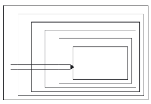
CLIMATE
ROCK
RELIEF
GROUNDWATER
SOIL
VEGETATION
Fig. 3.6
Dependence of vegetation on major factors.
Note that the relationships are not symmetrical.
Higher-order factors determine lower-order factors to a
much higher degree than vice versa.
3.4 Patterns
Actual landscape patterns are often very complicated
and are caused or governed by major factors and com-
plex interactions between them. At the same time
the relations between these factors are not sym-
metrical (Fig. 3.6). Factors of a higher order such as
climate and geology have a much larger impact on
lower-order ones like hydrology and soil type than vice
versa. This leads to a repetition of patterns of lower-
order elements given a certain similar constellation of
higher-order ones. One can observe for instance a large
degree of similarity between little-disturbed land-
scapes in the north-eastern part of the USA and their
equivalents in southern Scandinavia. The climate is
quite similar in these two areas and the geomorpho-
logy of both regions is determined by glacial activity
during the last ice age. At the same time this nat-
ural template is increasingly influenced by another,
independent dominant factor, namely human impact.
Climatic conditions and geomorphology in New
Jersey may not differ much from those in the area
around Helsinki, but this does not mean that the actual
landscapes are very similar. Differences in population
density, types of land use and history result in com-
pletely different landscape patterns in Manhattan and
villages near Helsinki.
Having said this, there is often a remarkable sim-
ilarity in vegetation patterns, both over larger areas
and over larger timescales. If only one major envir-
3.5 Landscape development
3.5.1 Natural landscapes
The actual geomorphologic structures in North
America and the northern half of Europe are almost
entirely the result of erosion and sedimentation pro-
cesses during the last glacial period. Glaciers and polar
deserts were the dominant landforms by then and the
climatic conditions were so harsh that hardly any
organisms could persist. The great majority of organ-
isms had to (re)colonize the released area during the
following interglacial period and trees in particular
have been quite successful. Delcourt and Delcourt
(1983) and Davis
et al.
(1986) have presented a
detailed reconstruction of this process. They showed
that colonization rates differed significantly between
species and this might explain actual differences in
tree distribution to a certain degree. Several studies
on dispersal and establishment (e.g. D'Antonio
et al.


