Environmental Engineering Reference
In-Depth Information
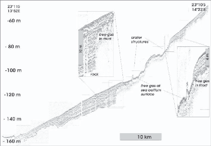
Figure 11.
SES96 Sediment echosounder profile 2: cross section of the mud belt at 23
◦
10'S,
showing pockmark/crater structures and abundant gas blankings.
pockmark structures covers about 380 km
2
. Pockmarks occupy 5 to 10 percent
of this area. The total gas-filled area has been estimated to cover as much as
1350 km
2
[14]. Free gas in the shelf sediments is restricted to an area between
22
◦
S and 23
◦
15'S between 40 m and 120 m water depth. Outside this area,
a small patch was detected off Conception Bay at 24
◦
S. Our data coverage
is considered sufficiently tight to predict that no large gas-filled areas have
remained undetected between 22
◦
and 27
◦
S.
7. TRANSPORT MECHANISMS OF HYDROGEN
SULPHIDE TO THE WATER COLUMN
7.1 Catastrophic Methane Eruptions
Video observations of rising gas bubbles, sediment craters, and disrupted
seafloor off Walvis Bay suggest locally enhanced transport of hydrogen sulphide
and methane by eruptive degassing. A budget assessment of the available
amount of hydrogen sulphide in the sediments is instructive to estimate the
reservoir strength of the mud belt for the supply of hydrogen sulphide to the
overlying water column. The gas-charged sediments, which cover 1350 km
2
(Table 2a) would contain about 2.0 · 10
11
moles hydrogen sulphide, if porewater