Environmental Engineering Reference
In-Depth Information
located over the Sakaraya submarine canyon) while others are more temporally
and spatially variable (e.g. the Sevastopol Eddy) [46]. Mesoscale coastal anti-
cyclonic eddies that move with the Rim Current are usually observed along the
Caucasus coast in the NE region of the Sea.
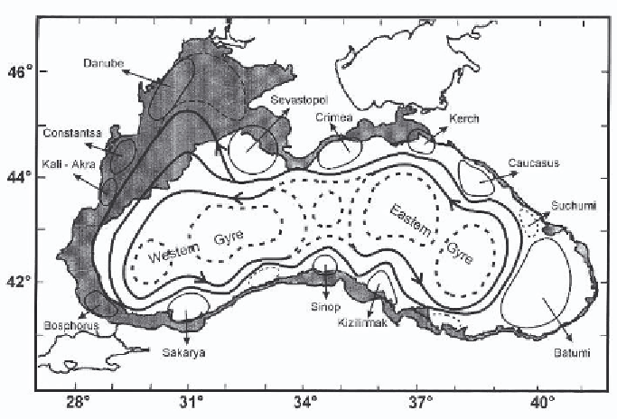
Figure 3.
Chart of the Black Sea showing the wind-driven Rim Current which flows in
a cyclonic or counterclockwise direction and several of the main anticyclonic gyres that are
located between the Rim Current and the coast. The shelf area (
<
300 m) is shaded dark [from
27].
As a result of this surface circulation individual subsurface density surfaces
are deeper around the margins and shallower in the central regions. All charac-
teristic features tend to be deeper near the margins and shallower in the central
gyres but they almost always fall on the same density levels. Thus, density is
usually used as a depth coordinate in the Black Sea. Plotting properties against
depth in the Black Sea produces a scatter of data, but when plotted against
density, the same data shows much less variability [10].
The Black Sea has an estuarine type circulation. Water flows in at depth
and out at the surface. The high salinity water (S = 35) that flows through the
Bosporus is also relatively warm (
15
◦
C). The rivers are the main source of
fresh water (300 km
3
y
−
1
) and they mostly drain onto the NW shelf where
the surface water can get relatively cold (5.5
◦
C) in the winter. On average the
lower layer inflow through the Bosporus to the Black Sea is about 313 km
3
y
−
1
∼