Environmental Engineering Reference
In-Depth Information
Substantial valley glaciation with tidewater glaciers at sea level occurs polewards of 50°
in southern Chile and Alaska. The St Elias and Juneau icefields of Alaska are among the
largest outside polar circles (Plate 25.2). Rapid sea-floor spreading and subduction (5-10
cm a
−1
in the Andes and 5-7 cm a
−1
in North America) promote continuing active uplift
(10-70 cm ka
−1
in the Andes and 30-60 cm ka
−1
in western North America). This is
accompanied by seismo-volcanic activity, rapid fluvial and glacial erosion and highly
unstable slopes outside the intermontane plateaux (see Colour Plate 6 between pp. 272
and 273). Both cordilleran systems inevitably have a major impact on
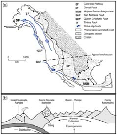
Figure 25.2
General structure (a) of the North American
cordillera, with (b) a representative west-east cross-section.
Source: Partly after Howell (1995).
global and continental climate, and act as the principal continental watersheds in both
orographic (enhanced rainfall) and topographic senses. Watershed asymmetry divides
many shorter, swift Pacific coast rivers from the few, massive basins draining to the
Arctic and Atlantic Oceans and the Gulf of Mexico. Intermontane basins in both
continents typically direct inland drainage networks into large and usually saline lakes
such as Titicaca, Poopo and Salar de Atacama (Andes) and Great Salt Lake (USA).
EURASIA: PYRENEES, ALPS AND HIMALAYAS
Alpine and Himalayan mountain systems represent intercontinental collisions, through
indentation and A-subduction of one plate into another accompanied by widespread
thrusting, terrane displacement and epeirogenesis. The direction of thrusting and
subduction changed during 'Afro-European' collision. Microplates were detached and
jostled each other as contacts were made elsewhere. The African plate moved first east,