Environmental Engineering Reference
In-Depth Information
glacial ice retreated
c
. 15 kyr ago. Thin layers are intercalated with late Pleistocene and
early Holocene palaeosols over much of southern and western Britain and provide useful
stratigraphic and palaeoclimatic indicators.
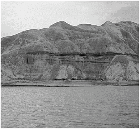
By comparison, accumulations exceeding 330 m depth in places form the great loess
sheets of China, which cover over 0·8 million km
2
(Plate 1). Basal units date from the
Pliocene-Pleistocene boundary 1·8-2 Ma ago and reflect sustained, if not uniform,
deposition throughout the Quaternary cold stage. This may emphasize the importance of
increasing desiccation in the Tibetan plateau rain shadow, leading to deflation of general
weathering and erosion products, rather than glacial sources. Some areas are also
downwind of more conventional sand and stone deserts. Accumulation reached a peak of
0·5-3 m ka
−1
during the periods of arid, cold climates during glacial maxima, falling by
65-80 per cent during intervening temperate stages. The diagnostic value of loess
deposits allows us to differentiate between previous glacial or cold arid climates, whilst
their geographical distribution permits the reconstruction of Quaternary atmospheric
circulation. To assist in both applications, the episodic delivery of loess conveniently
buried soils and vegetation in its path, facilitating the dating and further environmental
reconstruction of events.
Plate 1
Thick loess overlying late Tertiary clays uncomformably in
the Yellow River basin, China.
Photo: M. A. Fullen.
SAND BED FORMS: DUNES AND RIPPLES
At first sight, bed forms are very similar to those found on beaches or alluvial river beds
but on a far larger scale. As with all bed forms, they reflect particle size, fluid velocity