Environmental Engineering Reference
In-Depth Information
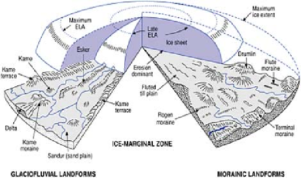
The landsystem is best developed, however, in Zone IV (Figure 15.10). Inner, active
parts of piedmont glaciers frequently operate over a range of basal shear stresses at which
thick lodgement till sheets can form and be deformed, most notably into drumlins parallel
to ice flow. This contrasts sharply with transverse depositional landforms in outer,
progressively more inactive and even stagnant ice areas at and behind the terminus. The
latter commence with
Rogen moraines
, representing transverse crevasse and shear plane
melt-out in compression zones behind a static terminus. Transverse
De Geer moraines
are formed where ice sheds debris beneath a floating tongue in ponded meltwater (Figure
15.11). The glacier terminus may be marked by one or more moraines or a
kame
moraine
composed largely of glaciofluvial sediments. The decisive shift from
ice-
contact
to
waterlain
facies commences with surviving casts of subglacial meltwater
streams, moulin fillings and ice-marginal streams. They form eskers,
kames
and
kame
terraces
respectively, with internal structures reflecting ice-wall collapse. Ice melt-out
and disintegration are marked by chaotic mixtures of till and waterlain sediments with
few clear landforms, giving way abruptly beyond the terminus to a
sandur
plain of
wholly glaciofluvial sediments. The sequence of down-glacier facies reflects changes
from subglacial to melt-out/ ablation, glaciolacustrine, glaciofluvial and even aeolian
environments. The alignment of clasts, trails of
erratics
derived from rocks upstream and
fining-downstream trends within glacigenic sediments provide palaeocurrent signatures
of ice sheet source and flow directions.
The dynamics of glacier sedimentation in British and other piedmont zones are of
contemporary interest because of their links with glaciomarine processes. The great
variability in sediment type and source, clear evidence of deformation during/after
deposition and the occasional presence of arctic marine shells may point to a catastrophic
collapse of the western British ice sheet during deglaciation. It is thought that rising sea
level flooded the northern Irish Sea basin faster than ice retreat, turning the ice margin
into a floating shelf (see box, p. 329, Figure 1c). This may have led first to accelerated
iceberg calving and then to ice sheet surging as its frontal support collapsed. Drumlin
fields in neighbouring low-lying parts of Ireland, northern England and north Wales