Environmental Engineering Reference
In-Depth Information
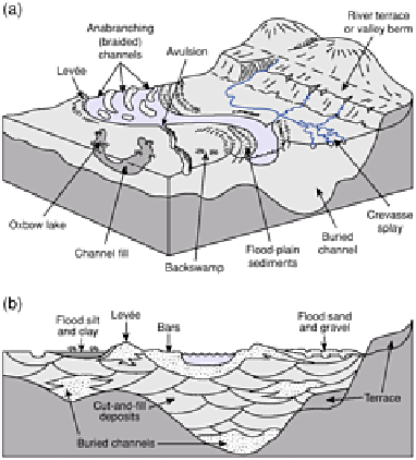
segments. Vertical aggradation buries and thereby envelops older deposits, mostly by
suspended sediment, and develops a convex floor
falling
away from the channel. Indeed,
raised banks or levées may form as coarser debris is deposited alongside the channel,
rendering low-lying areas poorly drained. Levées 10
1-3
cm high raise the threshold of the
next over-bank flood. Water cuts
crevasses
at low or weak points to regain the channel,
restarting the process with
crevasse splays
. The composite, three-dimensional floodplain
landsystem is shown in Figure 14.22. Flood plains end where the trunk stream enters the
ocean via an estuary or delta (see Chapter 17).
CONCLUSION
Flowing water and its geomorphic activity have been central to human life since
prehistoric hunters exploited their prey concentrations around riparian watering holes.
Alluvial sediments are important archaeological sources
Figure 14.22
Floodplain (a) morphology and (b)
stratigraphy.
for their artefacts, succeeded by widespread early to mid-Holocene evidence of the first
farmers. Since then, extensive flood plains have become sites of intensive human
settlement, agriculture and industry. In exploiting the fertile alluvium, sand and gravel
resources, ready access to water and sites suitable for urban, industrial and
communications infrastructure of river corridors we also contend with the fickle
behaviour of stream flow and channel instability. Human actions manage and reroute
stream flow but often also alter channel dynamics and sediment flux inadvertently. The
relative safety of higher river terraces contrasts with direct and human-enhanced flood