Environmental Engineering Reference
In-Depth Information
from the 'instantaneous' rate and the precipitation pattern is a function of catchment
controls on lag time and routing towards or away from the channel system. The
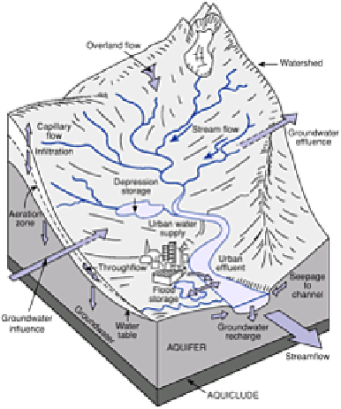
hydrological system ought to be one of the most easily understood open systems of
energy and material transfers in the physical environment. In essence, water passes from
available store to store, in sequence via a set transfer route as the capacity of each is
reached. In
Figure 14.3
The catchment landsystem.
practice, the land surface and its cover of vegetation or buildings disguises much of the
system. We can measure quantities and rates at a limited number of visible points but
depend mostly on estimates or extrapolations.
HYDROMETEOROLOGICAL TRANSFERS
The (
P
-
E
) portion of the water balance deals with primary
hydrometeorological
transfers between atmosphere and catchment (precipitation inputs and evapotranspiration
outputs).
Precipitation
is the total atmospheric input of water or water-equivalent mass
(snow, ice) and varies according to volume, type, intensity, frequency and annual regime.
Specific parameters are measured at
points
in the landscape by rain gauges.
Area
estimates are provided by radar assessment of rainfall intensity, or gauge-and-radar
combinations with ground truth from gauges refining radar estimates. Data expressed as
millimetres of water depth or rates in mm hr
-1
are directly applicable only to the point or
area concerned. However, total catchment data are required for most purposes. Area
estimates are therefore made using statistical weightings, which reflect catchment