Environmental Engineering Reference
In-Depth Information
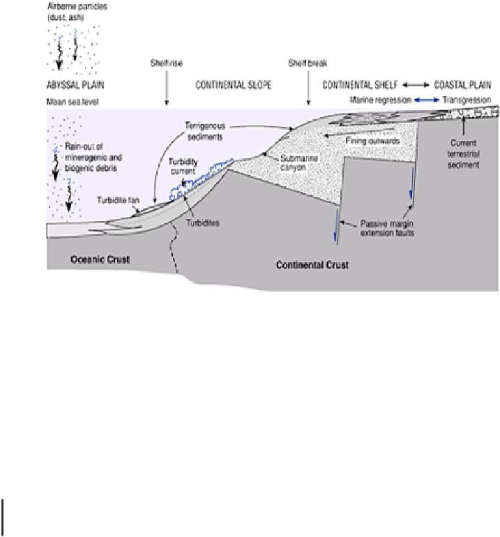
Ocean-continent boundaries have a fluctuating coastline and characteristic offshore
slope system covering over 20 per cent of ocean area. The
hypsometric curve
of
area/height distribution suggests that the continental shelf and
coastal plains
are
continuous features and that the principal boundary occurs at the continental shelf break
at approximately −200 m depth and on average 70 km from the shore. Below this, the
continental slope
inclines at 3°-6° towards the abyssal plain, which it meets at the
continental rise
. Shorter elements of this model occur in trench-arc coastlines but it is
most applicable to passive continental margins. The entire zone is draped with
terrigenous sediments
, sourced from land, in a transitional assemblage between
terrestrial and marine environments through marine
transgression
(advance) and
regression
(retreat) across the zone. Bedrock channels with sediment infills incise both
shelf and slope alike. The former are likely to be the
buried channels
of rivers cut during
lower sea levels but the latter are invariably
submarine canyons
formed by marine
processes alone (Figure 11.5).
Figure 11.5
The continental margin landsystem on a 'trailing
edge' (passive margin) coast.
OCEAN BASIN GEOMETRY AND SEA LEVELS
The position of the coast is determined by
sea level
, which, in turn, is dependent on
ocean water volume and ocean basin geometry. After hydrogen outgassing from the early
Earth probably reduced initial water volume by 30 per cent, sea level fluctuates now over
the following fundamentally different time scales.
1
Short
-
waves
and
tides
operate over 10
−6− −1
years (minutes-year); diurnal and
monthly tides are the most regular and waves are driven largely by wind.