Environmental Engineering Reference
In-Depth Information
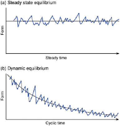
Figure 1.7
Types of equilibria in physical geography
Source: After Chorley et al. (1984).
and the river achieves equilibrium, maintaining a constant long profile.
However, changes in median grain size and channel gradient with increasing discharge
are related to each other not in terms of simple cause and effect but by much more
complex feedback relationships. Over long time scales it is preferable to apply the 'slope
evolution' model to rivers over the 'hydraulic geometry' model, especially over time
scales of hundreds of thousands of years, i.e. over
cyclic time
. This approach highlights
the decrease in grain size downstream as the cause of changing (i.e. reduced) gradients
downstream. As attrition and abrasion of particles in a river's load lead to a reduction in
the median grain size downstream, a particular discharge needs less of a channel slope to
mobilize the same sediment load. As a result, the channel gradients decrease over time,
by deposition of sediment in lower reaches and downcutting in upper reaches, so as to
maintain the graded river.
The relationships discussed can be expressed in terms of a process-response systems
diagram of an alluvial channel system (Figure 1.8). The attributes and variables are in the
boxes in the usual manner, with arrows showing the direction of the influence, whether
one-way or reversible. The plus and minus signs show direct (positive) and inverse
(negative) relationships respectively.
However, controls can change rapidly, leading to changes in the landscape element at
such rapid rates that the changes can be measured. Thus modern approaches to studying
environmental systems involve recording change in the field by experiments, by
analysing the large amounts of data by computers, by constructing mathematical models
of the landscape, and by simulating landscape processes by numerical methods.
For purposes of simulation and numerical modelling, it is necessary to express the
relationships which control the shape of long profiles of rivers as mathematical equations.
Hack (1957) proposed an empirical relationship to explain the slope of a river channel: