Environmental Engineering Reference
In-Depth Information
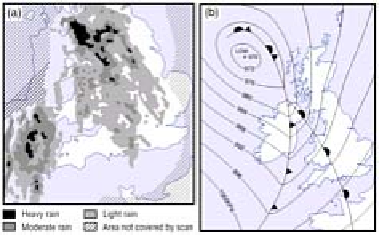
Figure 7.9
Precipitation patterns obtained by radar
associated with a mid-latitude cyclone over the British Isles.
Source: After Browning (1985).
typical banded precipitation of the warm front (Figure 7.9). However, farther away from
the depression, the intensity of uplift declines and cloud may gradually thin as the front
dies out. In this stage of only weakly rising air the front is termed a
kata-front
and the
transition zone of temperature is fairly broad (Figure 7.10). Rainfall is slight from kata-
fronts, as the clouds are not deep enough and the updraughts are weak.
In most depressions the air behind the cold front has an anticyclonic trajectory. This
allows the air to travel at supergeostrophic speeds, pushing the cold front more rapidly
than the warm front. The air of the warm sector is raised above the ground surface as the
cold front catches up with the warm front. This is known as the stage of
occlusion
, or the
occluded front
. The nature of the front will now depend upon the relative temperatures of
the two cold air masses (Figure 7.11). Where the air behind is colder than that ahead, we
will have a structure rather like a cold front. If it is warmer than the air ahead, the
structure will resemble a warm front.
The detailed air movements and cloud distribution at an occluded front are structurally
complex. As fronts represent the mixing of air of different origins, humidities,
temperatures and stabilities, it is not surprising that great variation can occur between
fronts, or even along the same
Figure 7.10
Cloud structure at a kata-warm and a kata-cold
front. An ana-frontal structure is shown in Figure 7.6.