Database Reference
In-Depth Information
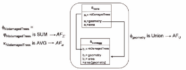
Figure 9. Correct Geographic Aggregation Mode on Time dimension and using spatial union
Definition. (OverlayGeoObjects)
OverlayGeoObjects is a function which takes
as inputs n Geographic Entity Instances represent-
ing n maps and returns m≥ n Geographic Entity
Instances whose geometries are obtained using
the Union Overlay.
Figure 4 shows the results of the
Overlay-
GeoObjects
function on geographic objects of
figure 3.
We present now the two
Geographic Aggre-
gation Modes
for our case study: the first uses
union and the second intersection. We show how
the
Geographic Aggregation Mode constraints
oblige the user to use sum only in the first case.
Moreover, these examples show how the user is
forced to aggregate the number of trees consider-
ing the semantics of the attributes and the used
dimensions.
Example 6.
Let us consider the query “
Where
and how many trees have been damaged by some
fires during 1978
?” (Query 1,
cf.
Sec “Research
Motivations”). We define a
View
with a
Correct
Geographic Aggregation Mode
, which uses aver-
age for the
Vertical Aggregation
and sum and union
for the
Horizontal Aggregation
(Figure 9).
Formally, let V
zones-year
= áBC
naturalrisks
, áS
phenomenon
,
S
year
ñ, Θ
zone
, γñ represent the Query 1 where:
•
Aggregation Mode Θ
zone
=
áS
zone
, S
zone_agg
, Φ
union
ñ where Φ
union
is (Figure
5)
1. ϕ
geometry
: dom(S
zone
.geometry)
n
→
dom(S
zone_agg
.geometry) is Union
Geographic
•
geometry
is AF
U
(spatial aggregation)
2. ϕ
nbDamagedtrees
: dom(S
zone
.geometry, S
zone
.
nbDamagedTrees)
n
→ dom(S
zone_agg
.nb-
DamagedTrees)= φ
nbDamagedTrees
where:
ϕ
•
φ
nbDamagedTrees
is SUM
•
κ
nbDamagedTrees
= Average
The multidimensional query V
zones-year
defines
a
Correct Geographic Aggregation Mode
because
the
Geographic Aggregation Mode Constraints
are satisfied:
1. κ
nbDamagedTrees
∈
AF
ω
=Min(DimensionType(n
bDamagedTrees,S
year
,S
type
)
(It is not possible to apply the sum operator
to numbers of trees because this measure is not
additive on time dimension)
2. φ
nbDamagedTrees
∈
AF
∑
=SpatialType(AF
U
,Min(
SemanticsType(nbDamagedTrees)))
(It is possible to apply the sum to the numbers
of trees for the geographic objects resulting from
VerticalAggregation
because the spatial function
is union and it is a spatial aggregation)
The Geographic Aggregation Mode Θ
zone
uses
•
DimensionsMeasure(nbDamagedTrees,
S
year
, S
type
) =
AF
ω
SemanticsMeasure(nbDamagedTrees)
•
=
AF
∑
Search WWH ::

Custom Search