Database Reference
In-Depth Information
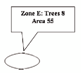
Figure 6. Aggregation of park's zones on the time
dimension
To best of our knowledge, no work deals with
this problem.
As discussed in Section “Related Work”, exist-
ing spatio-multidimensional models (Abello et al.,
2006; Damiani & Spaccapietra, 2006; Pourabbas,
2001, Sampaio et al., 2006, Silva et al., 2008)
do not introduce any constraint on spatial and
alphanumeric functions.
Jensen et al. (2004) do not extend aggregation
constraints for spatial measures. Moreover, since
the model provides a symmetrical representation
of measures and dimensions and since it does
not support dimensions attribute, each attribute
of a geographic object has to be represented as a
dimension which implies aggregating attributes
separately. This means that the model cannot sup-
port the dependency of spatial and alphanumeric
functions in the aggregation process.
Only Pedersen & Tryfona, (2001) model the
dependency of spatial and alphanumeric functions,
but as described above, they restrict spatial func-
tions to union, discarding spatial disaggregation
functions. This limits the analysis capabilities of
the model because, as shown by our case study,
spatial disaggregation functions could be neces-
sary for spatial analysis.
•
Step 1: Calculate disjoint geographic ob-
jects Calculate the set of geographic ob-
jects whose geometries are obtained using
the intersection operator on the geographic
measures (i.e.Figure 3). Alphanumeric at-
tributes are calculated using user-defined
functions. Geographic objects with the
same geometry and coordinates could be
created.
•
Step 2: Vertical Aggregation Geographic
objects created at step 1 with the same ge-
ometry and coordinates are unified to create
one geographic object, by applying an ag-
gregation function (κ) to the alphanumeric
attributes (i.e.Figure 4). These aggrega-
tions have to be coherent with the seman-
tics of the measures and with the dimen-
sions used in the multidimensional query
(Semantic of the measures “∑, ω, c
data”
cf. Sec. “Multidimensional Models”).
correct geogrAPhIc
MultIdIMenSIonAl AggregAtIon
In this section we introduce the base concepts
of the logical multidimensional model GeoCube
(Bimonte et al., 2006) and its extension to cor-
rectly aggregate geographic measures.
•
Step 3: Horizontal Aggregation Aggregate
the geometries of original geographic mea-
sures. Aggregate the alphanumeric attri-
butes of the geographic objects created at
step 2 (i.e.Figures 5 and 6). The alphanu-
meric aggregations (φ) have to be coherent
with the semantics of the measure (∑, ω, c)
and with the used spatial function.
An overview of the geocube Model
Bimonte et al., (2006) present a logical multidi-
mensional model called GeoCube, which supports
measures and dimension members as geographic
objects.
GeoCube
allows the usage of a set of
spatial and/or alphanumeric attributes as one
single complex measure (
geographic measures
).
It is important to underline that this process
can be applied also to lines, points, etc.
Search WWH ::

Custom Search