Database Reference
In-Depth Information
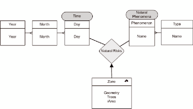
Figure 1. Multidimensional application with a geographic measure
spatial levels are related by topologic inclusion or
intersection relationships (Malinowski & Zimányi,
2005). An example of spatial hierarchy is French
administrative organization, which groups cities
into departments and departments into regions. A
topological inclusion relationship exists between
these geographic objects.
Spatial data can be also used as analysis subject
using the concept of
spatial measure
. Different defi-
nitions of spatial measure can be found in literature:
a collection of pointers to spatial objects or the result
of topological or metric operators (Bédard et al.,
2001; Malinowski & Zimányi, 2004; Stefanovic et
al., 2000). In (Bimonte et al., 2006), the concept of
geographic measure
is introduced as a geographic
object representing a real world entity and described
by some alphanumerical attributes and geometry.
Aggregation of geographic measures corresponds
to the aggregation of their alphanumeric and spatial
attributes by means of classical, spatial and user-
defined aggregation functions.
An example of SOLAP application concerns
the monitoring of natural phenomena in a park
(Figure 1). The dimensions of that spatio-multi-
dimensional application are time and the type of
phenomenon (e.g. fire, landslide, etc.). “Time”
dimension is described by a calendar hierarchy
(“Day” < “Month” < “Year”). “Natural Phenom-
ena” dimension groups phenomena (i.e. fire,
avalanche, etc.) into categories of phenomena
(i.e. dangerous, etc.).
The measure is the damaged zone, which is
described by a geometry, the number of damaged
trees and the area. The area is a derived measure
as it is calculated using other measures (Abello et
al., 2006). Then, to calculate the area for the ag-
gregated geographic object, no aggregation func-
tion is applied. It is calculated using the geometry
resulting from the spatial aggregation.
Figure 2 shows an example of the facts table
and the cartographic representation of two geo-
graphic measures.
The model allows users to answer queries like:
“
What regions have been damaged by fires during
1978 ?
”. This query implies the aggregation of the
geometry and the number of damaged trees.
Some works study the aggregation of spatial
and numerical measures in spatial data warehouses.
Performance is fundamental for SOLAP analysis.
Then, several authors, focusing on numerical
measures and spatial dimensions, integrate spatio-
temporal indexes with pre-aggregation techniques
Search WWH ::

Custom Search