Environmental Engineering Reference
In-Depth Information
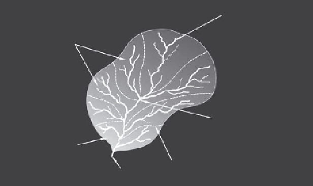
Headwater region
- Steep slope
- Lowest flow
- Erosion > deposition
Sub-basins
Transport zone
- Slope decreases
- Flow increases
- Erosion ≈ deposition
Depositional zone
- Minimal slope
- Highest flow
Sub-basin divide
Outlet
- Erosion < deposition
FIGURE 3.8
Watershed regions and transport functions.
Watershed
divide
Surface
flow
Surface
flow
Tributaries
Groundwater flow
FIGURE 3.9
Two adjacent watersheds.
basin, or water basin. For consistency and to avoid the use of a thesaurus, we use the term
watershed throughout the topic. Figure 3.9 shows two adjacent watersheds to illustrate
their structure and flow patterns at the surface and below (Alley 1999).
The entire land surface of the Earth can be subdivided into watersheds. Some of the
more notable watersheds in North America include those drained by the rivers listed
in Table 3.2 (Kammerer 1990). Figure 3.10 shows the major watersheds of the United
States.
Whether water drains off the land into successively larger watersheds or drains from a
watershed like the Mississippi, it ultimately discharges into an ocean. The Atlantic Ocean
receives surface water from 47% of the land surface of the world and the Pacific and Indian
Oceans each drain 13% of the land surface. The remaining surface drainage either ends
up in the Arctic Ocean or does not reach an ocean. Non-ocean bound surface water drains
into enclosed basins, such as the Great Basin located in the western portion of the United
States (Kammerer 1990).


Search WWH ::

Custom Search