Environmental Engineering Reference
In-Depth Information
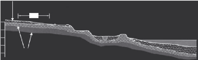
Sand
(m)
Site
220
200
Lake Michigan
Clay
180
FIGURE 14.17
Geologic cross section of Case Study 4 site.
sand deposit originated from beach and reworked beach deposits from fluvial processes.
Groundwater was encountered at depths of less than 1.5 m (5 ft) across the site. Figure 14.17
is a west to east geologic cross section of the site showing the location and relative thick-
ness of the geologic layers and the proximity of the site to the large surface water body.
Storm sewers and building foundations significantly influenced groundwater flow
across the site. The leakage of groundwater into the storm sewers at several locations pro-
vided an anthropogenic pathway for contaminants in groundwater and resulted in the
discharge of contaminants into a large surface water body located less than 1 km (0.6 mile)
away. On a more positive note, the building foundations effectively prevented the develop-
ment of large groundwater contaminant plumes because they extended only to the base of
the sand, where further downward migration was prevented by the basal clay.
Sources of contamination included sumps, pits, trenches, floor drains, and outdoor stor-
age of waste chemicals; many of these are identified in Figure 14.16. The remedial method
selected for soil was excavation since the contamination was accessible after demolition
and did not extend to depths greater than 3 m. Since the impacts were shallow due to
the anthropogenic influences just mentioned, excavation and pumping were used for the
remediation of groundwater.
The ultimate disposition of the site was influenced by its location within a residential
urban area and its proximity to a large surface water body. Continued use as an indus-
trial site was not feasible because of the site's residential location and lack of appropriate
highway access, so the surface structures were demolished and a portion of the site was
converted into a city park. Demolition had the effects of
• Speeding redevelopment.
• Lowering carrying cost.
• Minimizing trespass liabilities.
• Assisting in identifying and evaluating potential sources of contamination. There
had been more than 25 expansions conducted during facility history. Historical
engineering drawings indicated numerous potential historical sources of contam-
ination, and many were not available for inspection. These included former pits,
sumps, floor drains, tanks, and chemical storage areas.
• Lowering remediation cost by providing unobstructed access to all potential AOCs.
• Minimizing the potential for missing—or not properly investigating—all poten-
tial contaminant sources.
Search WWH ::

Custom Search