Environmental Engineering Reference
In-Depth Information
14.5 Case Study 4: Wisconsin
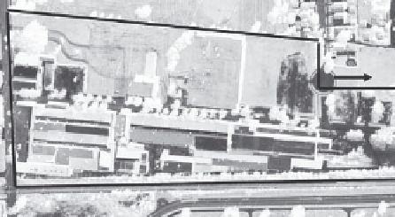
Case Study 4 is located in an urban area in Wisconsin (WDNR 2003). It became a
brownfield site when the plant was shut down after more than 80 years of operation.
According to available records, it was first developed as a heavy manufacturing facility
in the 1920s. Table 14.4 lists some basic information concerning the site, and Figure 14.15
shows the site.
This site is located in a geologically vulnerable area of moderate magnitude (vulnerabil-
ity rating = 55). Shallow groundwater is very near and hydraulically connected to a large
surface water body via anthropogenic means (storms sewers). No detailed urban geologic
map has been prepared for the region.
Investigation of this site began with a Phase I ESA that identified 25 recognized envi-
ronmental concerns and 15 locations of less significant concern. Three Phase II subsurface
investigations were conducted to find and define the nature and extent of contamination at
the site. Operations included drilling more than 300 soil borings, installing more than 100
groundwater monitoring wells, and collecting and analyzing more than 1000 samples for
TABLE 14.4
Site Characteristics of Case Study 1 Located in Wisconsin
Characteristic
Site Information
Location
Wisconsin
Years of operation
More than 100 years
Size of property
40 ac
Geologic setting
Lacustrine and fluvial sediments
Soil type and stratigraphy
Clay interbedded with some fine silt and sand layers
Contaminants detected
LNAPL and DNAPL VOCs, PCBs, PAHs, arsenic, lead,
cadmium, and copper
COC for soil
LNAPL and DNAPL VOCs, PAHs, SVOCs, PCBs, and lead
COC for groundwater
DNAPL VOCs
Depth to groundwater
Less than 1.5 m beneath the surface of the ground
Highest CRF
GW
ranking
DNAPL VOCs 1274
Highest CRF
SOIL
ranking
PCBs 1457
Geovulnerability ranking
55
Park
Residential properties
Case study 4 site
N
Cemetery and then large lake
FIGURE 14.15
Site map of Case Study 4.


Search WWH ::

Custom Search