Environmental Engineering Reference
In-Depth Information
Figure 14.12 shows the location of the site within a heavily urbanized area of mixed land
use. Heavy industry dominates the areas to the north and west of the site and residential
land use dominates the areas east and south. A shipping canal flowing north to a larger
surface water body borders the site along the western property boundary. The geology of
the site is dominated by lacustrine deposits of interbedded clay, silt, sand, and dune depos-
its. Depths of unconsolidated deposits are believed to be greater than 15 m (50 ft). Detailed
geologic mapping in three dimensions has not been conducted for the region. The direc-
tion of groundwater flow is west northwest toward the ship canal.
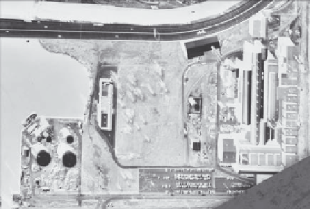
Figure 14.13 is a lower-altitude aerial photograph showing the facilities on-site.
Please note the presence of the transformer area at the right-center of the photograph.
Until their ban in 1979, PCBs were widely used as a fire retardant and insulator in the
N
N
Industrial
areas
Ship canal
Site location
(two parcels)
Industrial
areas
Industrial
areas
Residential
areas
Residential
areas
FIGURE 14.12
Aerial photograph showing the location and surrounding region of the Indiana site.
Roadway
Ship canal
Water tower:
Soil remediated
N
Transformer
area: Soil
remediated
Main
foundry
building
FIGURE 14.13
Facilities on-site.


Search WWH ::

Custom Search