Environmental Engineering Reference
In-Depth Information
vapor and CO
2
in the atmosphere, the pH of natural rainfall is slightly acidic at 5.6. Events
of acidic precipitation with a pH below 4.5 are common (USGS 2010), and pH values of
3.5 have been recorded in the eastern U.S. and Europe (Menz and Seip 2004). Due to the
logarithmic measurement scale, these values are 10-100 times more acidic than natural
precipitation.
The impacts of acidic precipitation on the landscape are significant. Acidic precipitation
interferes with the ability of vegetation to take up calcium and other soil base cations, has
led to widespread forest damage (Park et al. 2008), and damages to stream and lake eco-
systems (Keller et al. 2007; Deyton et al. 2009). Groundwater can also be impacted by acidic
precipitation, since the lower pH precipitation mobilizes many heavy metals in soil and
increases the risks of their transport into deeper groundwater (Kjoller et al. 2004).
12.2.2 The Surface and Subsurface
The collection and organization of precipitation performed by watersheds is enabled by
their topography and influenced by the regional climate and geology. In Figure 12.1, the
higher elevations shown as the watershed divide define the boundary of a surface water-
shed. It is within the “basin” created by the bounding high elevations where all precipi-
tation is collected. Any precipitation falling to the left of the watershed divide shown is
captured by the adjacent watershed.
Climate and geology interact to produce the drainage density and drainage pattern of a
watershed. Drainage density refers to the length of all channels within a specified area—
typically a square kilometer; drainage pattern is the arrangement of the stream channels.
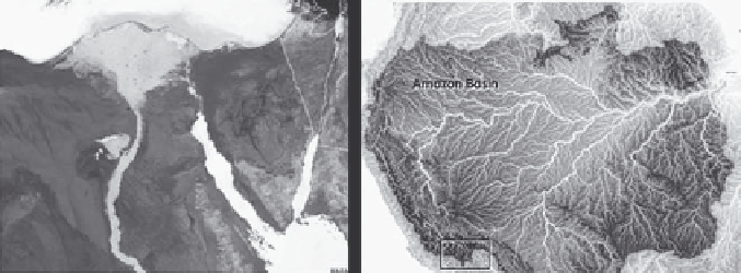
Rivers such as the Nile do not have many tributaries once they flow out of the Ethiopian
Highlands through the Sahara Desert (Figure 12.2a). In a region with higher precipita-
tion, the Amazon River requires several tributaries with more annual discharge than the
Mississippi River to collect the water (Figure 12.2b).
Regional geology largely determines the routes taken by flowing surface water. Over
time, a stream system develops a particular drainage pattern in response to the local
topography and subsurface geology. Three of the most common drainage patterns (den-
dritic, parallel, and rectangular) illustrate the relationship between geology and drainage
pattern. In the sedimentary geological environments where many urban watersheds are
located, the dendritic (treelike) drainage pattern is the most common form (Figure 12.3a).
(a)
(b)
FIGURE 12.2
Comparative drainage densities resulting from climate. (a) Nile. (From NASA/GSFC/LaRC/JPL, MISR Team.)
(b) Amazon. (From University of Maryland's Global Land Cover Facility and NASA http://earthobservatory.
nasa.gov/IOTD/view.php?id=7823)
Search WWH ::

Custom Search