Environmental Engineering Reference
In-Depth Information
Radius
Firm inside radius
and geo-unit
Firm outside radius
or geo-unit
+
Well at hazardous
site
Geo-unit boundary
+
SIC
Risk score
4.00
6.67
0.24
2822
3315
5198
Total 10.91
Sandy clay
Sand
Sandy and silty clay
N
0
20 km
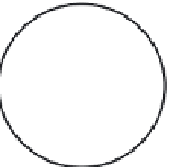
FIGURE 10.4
Calculation of surface risk using the risk values computed for specific establishment types within the capture
radius around a contaminated brownfield site.
The circle shown in Figure 10.4 represents the 10 year capture zone of a pumping well
located in the center of the circle. Circular areas may be effective in modeling wellhead
protection areas under small regional hydraulic gradients and low groundwater velocities
(Baringer at al 1990; Camp and Outlaw 1998). In this example, the capture zone was calcu-
lated by using existing data from hydrogeologic investigations conducted near the study
site, under the assumptions of a pumping rate that induces a hydraulic gradient of 0.1 m/m
in all directions toward the pumped well, a relatively level water table, and predominately
horizontal groundwater flow. It is also possible to derive the capture zone if the necessary
information on gradient, hydraulic conductivity, and effective porosity is obtained at the
site.
After an appropriate radius is established, an automated procedure for the surface risk
can be performed. This can be achieved by (1) geocoding a file containing the street
addresses of public, commercial, and industrial establishments (labeled “Firms” in
Figure 10.4) each coded by its SIC designation and (2) using the capabilities of a geo-
graphic information system (GIS) to sum the risk scores for each firm within the specified
radius on a digital map image (Kaufman 2000).
Table 10.1 lists the 10 year capture zones and mean surface risk values for four of the
most common soil types found in the Rouge River Watershed in southeastern Michigan.
TABLE 10.1
Surface Risk Values for the Rouge Watershed
10 Year Capture
Zone (km)
Mean Surface
Risk Value
Geologic Unit
Clay
0.03
0.04
Silty clay
0.06
33.70
Sandy silty clay
1.07
0.42
Sand
597.00
343.64


Search WWH ::

Custom Search