Environmental Engineering Reference
In-Depth Information
traditionally used spatially generalized categories of land use to represent various levels
of risk, such as industrial, commercial, residential, and recreational (Baringer et al. 1990;
Eckhardt and Stackelberg 1995; Secunda et al. 1998).
The use of general land use categories for vulnerability assessments is problematic
because of their inadequate
spatial resolution
, defined as the smallest identifiable element
in a sequence (Tobler 1988). In urban and urbanizing areas, mixed land uses within small
areas such as city blocks are common, so the variable risks may be obscured by generaliza-
tions when the capture zones for water supply wells, termed
wellhead protection zones
,
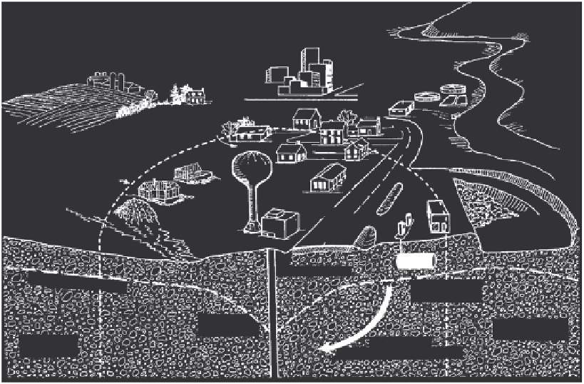
are delineated. For example, the 10 year capture zone is the subsurface and surface areas
from where water (and any contamination it carries) will reach the well over a time period
of 10 years. Figure 10.1 shows an example capture zone of a water supply well in an urban
area (Wisconsin Department of Natural Resources 1999). Figure 10.2 shows an example of
a recharge area in cross section (USGS 1998).
To demonstrate this problem of inadequate spatial resolution, we can consider a water
well in an area designated as for residential land use as depicted in Figure 10.3 (Kaufman et
al. 2003). Within this zone of low risk is a single and small industrial establishment engaged
in metal plating. Metal plating activities exhibit a high incidence rate of soil and groundwa-
ter contamination, but this specific risk is masked by the generalization of the area within
the capture zone as a lower-risk residential category. This is depicted in Figure 10.3a.
Figure 10.3b illustrates how two adjacent, but different zones create edge effects. At the
edge, the residential zone becomes exposed to the higher risks associated with industrial
land, but the sources and amounts of the actual risk from the industrial land near the edge
Municipal sewage
treatment plant
Urban
runoff
Lawn fertilizers
and pesticides
Agricultural
chemicals
Protection area
River
Urban
runoff
Road
salt
Sanitary
landfill
Municipal well
Underground
storage tank
Cone of
depression
Sand & gravel
aquifer
Zone of
saturation
Direction of
groundwater movement
FIGURE 10.1
Example capture zone. (From Wisconsin Department of Natural Resources (WDNR),
Wellhead Protection
, WDNR
Publication PUB-DG-039 99REV, Madison, WI, 1999.)
Search WWH ::

Custom Search