Environmental Engineering Reference
In-Depth Information
his auto plants, and built another dam to supply power to his mansion. After Ford bought
810 ha (2000 ac) along the lower Rouge west of Detroit in 1915, the River was dredged
near its mouth in 1918 in the area that was to become the Ford Rouge Complex (USEPA
2004b). Finished in 1927, the River Rouge plant consisted of nineteen separate buildings in
an industrial complex sprawling over more than 5 km
2
(2 mi
2
). The complex included the
aforementioned deep sea harbor; the world's largest steel foundry; 150 km (94 mi) of rail-
road track; and stamping, glass making, and auto assembly buildings.
At its peak, over 90,000 people worked at the Rouge, and the other members of the Big
Three automakers followed the format of building large facilities with large workforces.
By the 1920s, Dodge had built the 27 ha (67 ac) Dodge Main Plant in Hamtramck—a city
enclosed by Detroit and just a short distance from Ford's Highland Park facility where the
production line originated. Also during this period, General Motors constructed a large
plant on 19 ha (47 ac) in southwest Detroit to produce the Cadillac. After a downturn in
the industry during the Great Depression, the auto industry rebounded in the 1940s by
turning its energies to the war effort. Ford opened a bomber factory and Chrysler a tank
plant, leading to a new nickname for Detroit—“the arsenal of democracy”—a phrase made
famous in one of President Franklin Roosevelt's fireside chats (Davis 2007).
The centralization of auto production in Detroit (and Michigan) began to decline in the
1950s, as automakers sought ways to cut costs by moving factories to the suburbs and non-
union states, and avoiding situations where a strike at one plant could cripple the whole
industry (Sugrue 2005). These actions corresponded with the expansion of the national
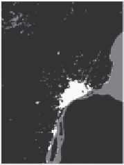
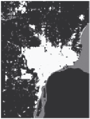
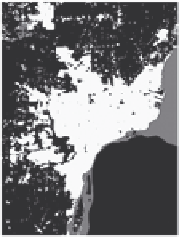
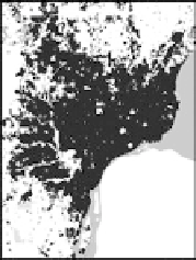
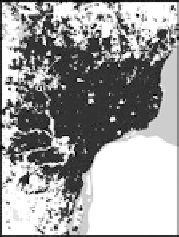
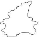
highway network and accelerated the growth of suburbs and urban sprawl. Figure 1.3
shows the history of developed land in southeast Michigan from 1905 to 1992. The shaded
areas represent area covered by “urban or built up land,” according to Anderson et al. (1976).
1905
1938
1952
1968
1980
1992
FIGURE 1.3
Developed land in southeast Michigan (1905-1992); Rouge watershed boundary is shown in the 1905 image
at the top left. (From Richards, L.,
Detroit River Corridor
,
Preliminary Assessment of Land Use Change
, Urban
Dynamics Research Program, USGS Ames Research Center, Moffett Field, CA, 2003.)

Search WWH ::

Custom Search