Environmental Engineering Reference
In-Depth Information
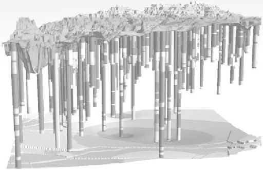
FIGURE 5.17
Mapping in three dimensions using boring logs. (From Great Lakes Geologic Mapping Coalition, Geologic
mapping introduction, Indiana Geologic Survey, http://igs.indiana.edu/GreatLakesGeology/introduction.
html, 2009.)
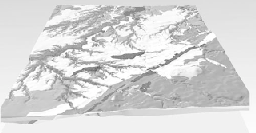
FIGURE 5.18
Three-dimensional geologic map. (From Great Lakes Geologic Mapping Coalition, Geologic mapping introduc-
tion, Indiana Geologic Survey, http://igs.indiana.edu/GreatLakesGeology/introduction.html, 2009.)
3. The dendritic drainage pattern of the Rouge watershed is similar to most inland
urban watersheds lying over sedimentary rock anywhere in the world (even
those not glaciated); coastal zones may be different because of regional tectonic
influences.
4. The trend or strike of the glacial and lacustrine deposits is generally from the
southwest to the northeast and follows the retreating ice as the glaciers melted.
5. The types of deposits change—sometimes significantly—over short distances. This
is evident from the map as the deposits vary from glacial to lacustrine to fluvial.
The advantages of a three-dimensional map compared to a two-dimensional map become
apparent by comparing Figure 5.16—a simplified three-dimensional map of the Rouge
River watershed—with the two-dimensional geologic map of the Rouge River shown in
Figure 5.20. These advantages include (1) showing the thickness of the sediment layers; (2)
showing formations, such as the Lower Clay Unit, which is not even represented in the
two-dimensional map; and (3) showing the dip, if any, of the geologic units.
Search WWH ::

Custom Search