Environmental Engineering Reference
In-Depth Information
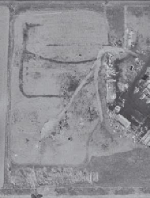
Closed
landfill cell
Crop field
Active
landfilling
(b)
(a)
FIGURE 4.3
(a) Aerial photograph showing farmland; (b) Earlier aerial photograph showing landfilling activities. (Photos
courtesy of Daniel T. Rogers.)
Historical aerial photographs are effective sources of information and often help with
environmental investigations. In urban areas especially, aerial photographs from several
sources are readily available. These sources include
• Private local companies specializing in aerial photography
• Private national companies specializing in aerial photography
• Local and state historical societies
• Local and state agencies
• Utility companies
• Local companies
• Federal agencies such as USEPA, USGS, Soil Conservation Service, National Forest
Service, Bureau of Land Management, and National Park Service.
Figure 4.3a and b demonstrate how historical aerial photographs can help identify RECs.
On the left, Figure 4.3a shows a particular property as farmland with no identifiable REC.
Analysis of an aerial photograph taken a few years earlier of the same property (Figure
4.3b to the right) indicates the property was used as a landfill, which is almost always
considered a REC.
4.2.2 Health and Safety
If the result of the Phase I ESA indicates further investigation is needed, a health and safety
plan must be prepared before the Phase II investigation can begin (Occupational Safety
and Health Administration [OSHA] 1989, as revised). This plan can only be prepared by
a qualified professional because onsite Phase II investigations are conducted at locations
containing physical and chemical hazards. The potential for exposure to these hazards
requires specialized health and safety training for personnel going into the field—an


Search WWH ::

Custom Search