Agriculture Reference
In-Depth Information
Figure 15. Irrigation water reuse ratio (%) in intake water from D.W. in a dry year
(1987, every 5 days average unit, Iwade D.W.)
Rainfall
100
0
80
20
60
40
40
60
20
80
0
100
June July August September
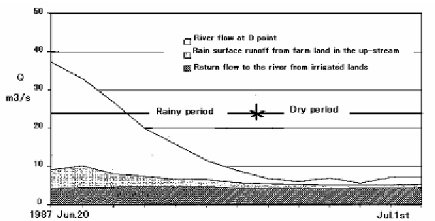
Figure 16. Transition of river flow and its component corresponding to
at Iwade
D. W. from June 20 to July 1 in 1987
The second study basin, the Kinu and Kokai River Basin, is located in the Kanto
Region in the central part of Japan. The report of the Tone River System Land
Improvement Examination and Management Office in MAFF (2003) describes that the
study basin area is the lower part of the basin with a catchment area of 1420 km
2
. The
Sanuki diversion work is located at the uppermost reach of the study basin area. Average
annual precipitation in the study basin area is 1200-1600 mm. There exist three reservoirs
in the upper reach of the Kinu River system and three main diversion works in the long
and narrow plain in the study basin area. The plain area accounts for 80% of the study
basin area. 51% of the plain area consists of 21,000 ha of paddy fields.


Search WWH ::

Custom Search