Environmental Engineering Reference
In-Depth Information
APPENDIX
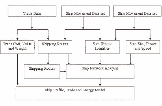
The STTEM makes use of ship empirical waterway data, maritime trade data, and ship attribute data.
With minor modifications to account for different attributes, the model is generalized in Figure 2. This
data for North American ship movement and trade are most easily available, so ship movement and trade
in the United States are used as an example.
Figure 2. The construction of the STTEM
The trade data comes from the Import Waterborne Data Bank published by the US Army Corp of Engi-
neers for trade information. The dataset documents the trade value and weight carried by ships to the
United States. It also records the export countries and ports as well as import ports and customs districts.
The foreign port and domestic customs district pairs from the Import Waterborne Data Bank are matched
with the Entrances and Clearances dataset described below, and refers to such pairs as the unique routes.
The six-level Harmonized System (HS6) classifies the commodity types.
The ship empirical movement data is from the US Entrances and Clearances dataset containing unique
ship information (i.e., IMO number), which includes over 90,000 records of arrivals and departures involv-
ing US ports and ships in foreign commerce. It documents some of busiest shipping lanes in the world.
Ship parameters such as power, speed, and ship size are from Lloyd's ship registry data to match ship
identifiers, and select information to specific ship voyages.
Where ship power is missing, the values are estimated for each vessel type by regressing the relation-
ships between GRT and NRT and between power and NRT. Where ship speed is missing, the values
are estimated for each vessel type by regressing the relationships among speed, power, and NRT. The
regression and results for GRT and NRT are shown in Table 6. The calculation of power and speed is