Environmental Engineering Reference
In-Depth Information
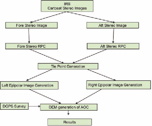
Figure 1. Methodology flow chart showing the AOC
in satellite technology have enabled scientists to
monitor changes in glacial retreat patterns using a
combination of Remote Sensing satellite imager-
ies. By superimposing past satellite data on present
maps, area of recession of individual glaciers is
estimated with a fair degree of accuracy using
techniques like image enhancement.
Recent studies have involved the use of high
resolution satellite data i.e. CARTOSAT -1 of IRS
(Indian Remote Sensing Satellite).CARTOSAT-1
satellite data with a 2.5m resolution with fore and
aft image stereo pair images, have been used to
generate the height information of an area. In
order to identify the land use and glacial spread
area it was also necessary to get the true color or
FCC (False Colour Composite) of that area. For
this purpose LISS III (Linear Image Self Scan-
ning) multi spectral data was spectrally fused with
the CARTOSAT PAN data, to give spectral four
band (including visible portion of electromagnetic
spectrum) output with 2.5m spatial resolution.
Apart from this a DEM (Digital Elevation
Model) from Cartosat -1 satellite data was created
by satellite define RPC (Rationalize Polynomial
Coefficient) technique. In the Cartosat - 1 stereo
pair consist two satellite fore and aft stereo pair
images and RPC file for both the images. In the
initial stage all these mentioned files were used
to generate tie point generation. Tie point are the
points which can be identified in both of the im-
ages and both the images can be georeferenced
on the basis of these tie points. At some places
we provided some tie points to the defined places
on the basis of the field survey points taken by
the DGPS (Differential Global Position System).
After the generation of tie point generation left
and right epipolar images was generated, which
was working as an input to DEM. Now the left and
right epipolar images were used to create DEM.
After creating DEM a 3-D model of AOC (Area
of Concern) was prepared and analyzed.
In India, Remote sensing studies using time
series data have provided valuable insights into
the retreat pattern of glaciers. (Kulkarni and Ba-
huguna,2002, Kulkarni et al., 2002). The use of
Differential Global Positioning Systems (DGPS)
based data also helps in determining snout posi-
tion / extent of a glacier resulting in a higher
degree of accuracy. GIS based technologies are
used in developing spatial databases on land use/