Database Reference
In-Depth Information
EXAMPLE
12.7 In
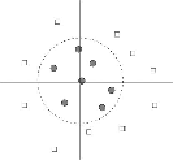
Fig. 12.10
we see a plot of places to visit from my home. The horizontal
and vertical coordinates represent latitude and longitude of places. Some of the places have
been classified into “day trips” - places close enough to visit in one day - and “excursions,”
which require more than a day to visit. These are the circles and squares, respectively.
Evidently, there is no straight line that separates day trips from excursions. However, if we
replace the Cartesian coordinates by polar coordinates, then in the transformed space of po-
lar coordinates, the dashed circle shown in
Fig. 12.10
becomes a hyperplane. Formally, we
transform the vector
x
= [
x
1
,
x
2
] into [
arctan(
x
2
/
x
1
)].
Figure 12.10
Transforming from rectangular to polar coordinates turns this training set into one with a separating hyper-
plane
In fact, we can also do dimensionality reduction of the data. The angle of the point is
irrelevant, and only the radius matters. Thus, we can turn the point vectors into
one-component vectors giving the distance of the point from the origin. Associated with
the small distances will be the class label “day trip,” while the larger distances will all be
associated with the label “excursion.” Training the perceptron is extremely easy.
□
12.2.7
Problems With Perceptrons
Despite the extensions discussed above, there are some limitations to the ability of per-
ceptrons to classify some data. The biggest problem is that sometimes the data is inherently
not separable by a hyperplane. An example is shown in
Fig. 12.11
.
In this example, points
of the two classes mix near the boundary so that any line through the points will have points
of both classes on at least one of the sides.