Geology Reference
In-Depth Information
cliff base, and the amount of abrasive material churned
up at the cliff-beach junction.
Ramps
occur at cliff bases and slope more steeply than
the rest of the shore platform. They occur on sloping and
horizontal shore platforms. Horizontal shore platforms
may carry ridges or
ramparts
, perhaps a metre or so high,
at their seaward margins.
Marine
potholes
are roughly cylindrical or bowl-
shaped depressions in shore platforms that are ground
out by the swirling action of sand, gravel, pebbles, and
boulders associated with wave action.
Caves, arches, stacks, and related
landforms
Small bays, narrow inlets, sea caves, arches, stacks, and
allied features usually result from enhanced erosion along
lines of structural weakness in rocks. Bedding planes,
joints, and fault planes are all vulnerable to attack by
erosive agents. Although the lines of weakness are eroded
out, the rock body still has sufficient strength to stand as
high, almost perpendicular slopes, and as cave, tunnel,
and arch roofs.
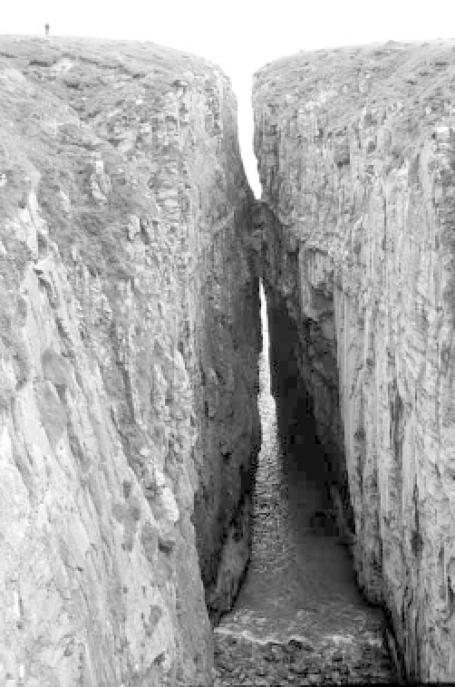
A
gorge
is a narrow, steep-sided, and often spectac-
ular cleft, usually developed by erosion along vertical
fault planes or joints in rock with a low dip. They
may also form by the erosion of dykes, the collapse of
lava tunnels in igneous rock, and the collapse of mining
tunnels. In Scotland, and sometimes elsewhere, gorges
are known as
geos
or
yawns
(Plate 13.5), and on the
granitic peninsula of Land's End in Cornwall, south-west
England, as
zawns
.
A
sea cave
is a hollow excavated by waves in a zone
of weakness on a cliff. The cave depth is greater than
the entrance width. Sea caves tend to form at points
of geological weakness, such as bedding planes, joints,
and faults. Fingal's Cave, Isle of Staffa, Scotland, which
is formed in columnar basalt, is a prime example. It is
20 m high and 70 m long. A
blowhole
may form in
the roof of a sea cave by the hydraulic and pneumatic
action of waves, with fountains of spray emerging from
the top. If blowholes become enlarged, they may col-
lapse. An example of this is the Lion's Den on the Lizard
Peninsula of Cornwall, England.
Plate 13.5
Geo at Huntsman's Leap fault cleft,
Castlemartin, South Dyfed, Wales.
(
Photograph by Tony Waltham Geophotos
)
Where waves attack a promontory from both sides, a
hollow may form at the promontory base, often at a point
of geological weakness, to form a sea arch (Plate 13.6).
If an arch is significantly longer than the width of its
entrance, the term '
sea tunnel
' is more appropriate.
Merlin's Cave, at Tintagel, Cornwall, England, is a
100-m-long sea tunnel that has been excavated along a
fault line. The toppling of a sea arch produces a
sea stack
(Plates 13.7 and 13.8). Old Harry Rocks are a group of
stacks that were once part of the Foreland, which lies
on the chalk promontory of Ballard Down in Dorset,
England. On the west coast of the Orkney Islands,
Scotland, the Old Man of Hoy is a 140-m stack separated
from towering cliffs formed in Old Red Sandstone.