Geology Reference
In-Depth Information
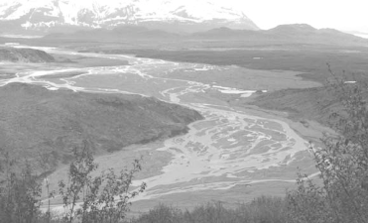
Plate 10.15
Braided outwash plain in front of, and to the side of, the snout of the debris-covered Casement Glacier,
Glacier Bay, Alaska.
(
Photograph by Mike Hambrey
)
conditioned by glaciation and deglaciation to fashion
paraglacial landforms
(see Ballantyne 2002). Once ice
disappears, several changes occur in former glacial land-
scapes. Rock slopes steepened by valley glaciers become
unstable and vulnerable to slope failure and rockfall once
the ice no longer acts as a buttress. Slopes bearing a man-
tle of drift but no vegetation become subject to rapid
reworking by debris flows, snow avalanches, and slope
wash. Glacier forelands become exposed to wind erosion
and frost action. Rivers pick up and redistribute large
amounts of unconsolidated sediment of glacial origin,
later depositing it in a range of terrestrial, lacustrine, and
marine environments. Wind entrains finer sediments,
particularly silts, and may bear it thousands of kilometres
and deposit it as loess deposits (p. 311). This accelerated
geomorphic activity follows deglaciation and lasts up to
10,000 years, until the landscape adjusts to non-glacial
conditions.
June M. Ryder (1971a, b) coined the term 'paraglacial'
to describe alluvial fans in British Columbia, Canada,
formed through the reworking of glacial sediment by
rivers and debris flows after the Late Pleistocene deglacia-
tion. Michael Church and Ryder (1972, 3059) then
formalized the idea by defining 'paraglacial' as 'nonglacial
processes that are directly conditioned by glaciation',
which includes proglacial processes and processes occur-
ring 'around and within the margins of a former glacier
that are the direct result of the former presence of ice'.
Moreover, they recognized a
'paraglacial period'
- the
time during which paraglacial processes operate. Later,
they extended the notion to include all periods of glacier
retreat, and not just the Late Pleistocene deglaciation
(Church and Ryder 1989).
Colin K. Ballantyne (2002) recognized six paraglacial
'land systems' - rock slopes, drift-mantled slopes, glacier
forelands, and alluvial, lacustrine, and coastal systems -
each containing a variety of paraglacial landforms and
sediment facies. Taken together, he regarded these land-
forms and sediments - talus accumulations, debris
cones, alluvial fans, valley fills, deltas, coastal barrier
structures, and so forth - as storage components within
an interrupted sediment cascade. The cascade has four
primary sources of material - rockwalls, drift-mantled
slopes, valley-floor glacigenic deposits, and coastal
glacigenic deposits. And it has four terminal sediment
sinks - alluvial valley-fill deposits, lacustrine deposits,
coastal and nearshore deposits, and shelf and offshore
deposits.