Geology Reference
In-Depth Information
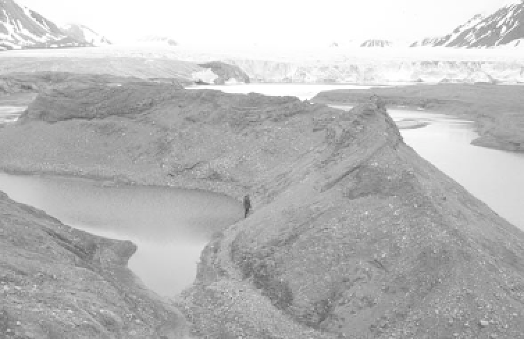
Plate 10.14
Esker made up of slightly deformed stratified sands and gravels near the ice margin of Comfortlessbreen,
Svalbard.
(
Photograph by Mike Hambrey
)
of sand and gravel and laid down in a meltwater tunnel
underneath a glacier. Some eskers form at ice margins,
and are not to be confused with kames and kame terraces
(see below), which are ice-contact deposits at the ice mar-
gin. In the past, confusion has beset the use of these terms,
but the terminology was clarified in the 1970s (see Price
1973 and Embleton and King 1975a). Eskers can run
uphill and sometimes they split or are beaded. They may
run for a few hundred kilometres and be 700 m wide
and 50 m high, although they are typically an order of
magnitude smaller.
as the ice. Lakes may form before the overflow occurs.
Until the mechanisms of subglacial drainage were under-
stood, channels found in formerly glaciated temperate
regions were ascribed to meltwater overflow, but many
of these channels are now known to have been wrought
by subglacial erosion.
Kames
The main depositional landforms associated with ice
margins are
kames
of various kinds (Figure 10.7).
Crevasse-fillings, which comprise stratified debris that
entered crevasses through supraglacial streams, are minor
landforms. Kames are commonly found with eskers.
They are flat-topped and occur as isolated hummocks,
as broader plateau areas, or, usually in proglacial set-
tings, as broken terraces. Individual kames range from
a few hundred metres to over a kilometre long, and a few
tens of metres to over a hundred metres wide. They have
no preferred orientation with respect to the direction of
ice flow. If many individual kames cover a large area, the
term 'kame field' is at times applied.
Kame terraces
develop parallel to the ice-flow direc-
tion from streams flowing along the sides of a stable or
Ice-margin landforms
Meltwater and overflow channels
Erosion by meltwater coursing alongside ice margins
produces meltwater channels and overflow channels.
Meltwater channels
tend to run along the side of
glaciers, particularly cold glaciers. They may be in contact
with the ice or they may lie between an ice-cored lateral
moraine and the valley side. After the ice has retreated,
they can often be traced across a hillside.
Overflow channels
are cut by streams at the ice mar-
gin overtopping low cols lying at or below the same level