Geology Reference
In-Depth Information
Hummockymoraines
, also called
dead-ice moraines
or
disintegration moraines
, are seemingly random
assemblages of hummocks, knobs, and ridges of till and
other poorly sorted clastic sediments, dotted with kettles,
depressions, and basins frequently containing lacustrine
sediment. Most researchers regard the majority of hum-
mocky moraines as the product of supraglacial deposi-
tion, although some landforms suggest subglacial origins.
Far-travelled
erratics
are useful in tracing ice move-
ments.
Second, they may be the result of textural differences in
subglacial debris. Third, they may result from active basal
meltwater carving cavities beneath an ice mass and after-
wards filling in space with a range of stratified sediments.
Some large drumlin fields, the form of which is redolent
of bedforms created by turbulent airflow and turbu-
lent water flow, may have been formed by catastrophic
meltwater floods underneath Pleistocene ice sheets (Shaw
et al
. 1989; Shaw 1994).
De Geer and Rogen moraines lie transversely to the
direction of ice flow.
De Geer moraines
or
washboard
moraines
are series of small and roughly parallel ridges
of till that are ordinarily associated with lakes or former
lakes.
Rogen moraines
, also called
ribbed moraines
and
cross-valley moraines
, are crescent-shaped landforms
composed largely of till that are formed by subglacial
thrusting. They grade into drumlins.
Various types of
ground moraine
display no particu-
lar orientation with respect to ice flow. A ground moraine
is a blanket of mixed glacial sediments - mainly tills and
other diamictons - formed beneath a glacier. Typically,
ground moraines have low relief. Four kinds of ground
moraine are recognized: till plain, gentle hill, hummocky
ground moraine, and cover moraine. Till plains are the
thickest type and cover moraine the thinnest. A review of
subglacial tills
argues that they form through a range of
processes - deformation, flow, sliding, lodgement, and
ploughing - that act to mobilize and carry sediment and
lay it down in a great variety of forms, ranging from
glaciotectonically folded and faulted stratified material
to texturally uniform diamicton (Evans
et al
. 2006).
Moreover, owing to the fact that glacier beds are mosaics
of deformation and sliding and warm- and cold-based
conditions, most subglacial tills are likely to be hybrids
created by a range of processes active in the subglacial
traction zone. Nonetheless, glacial geologists can identify
three distinct till types (Evans
et al
. 2006):
Subglacial landforms
A wealth of landforms form beneath a glacier. It is
convenient to class them according to their orientation
with respect to the direction of ice movement (parallel,
transverse, and non-orientated).
Forms lying parallel to ice flow are drumlins, drum-
linized ridges, flutes, and crag-and-tail ridges.
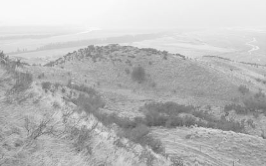
Drumlins
are elongated hills, some 2-50 m high and 10-20,000 m
long, with an oval, an egg-shaped, or a cigar-shaped out-
line. They are composed of sediment, sometimes with a
rock core (Plate 10.11), and usually occur as
drumlin
fields
, giving rise to the so-called 'basket of eggs' topog-
raphy on account of their likeness to birds' eggs. They
are perhaps the most characteristic features of landscapes
created by glacial deposition. The origin of drumlins is
debatable, and at least three hypotheses exist (Menzies
1989). First, they may be material previously deposited
beneath a glacier that is moulded by subglacial meltwater.
1
Glaciotectonite
- rock or sediment deformed by
subglacial shearing or deformation (or both) and
retaining some structural characteristics of the parent
material.
2
Subglacial traction till
- sediment released directly
from the ice by pressure melting or liberated from
the substrate (or both) and then disaggregated and
Plate 10.11
Rock-cored drumlin, New Zealand.
(
Photograph by Neil Glasser
)