Geology Reference
In-Depth Information
events, as well as predicting total runoff and soil loss
(Table 7.2). Many physically based soil-erosion models
have benefited from
GIS technology
.
Slope-dependent (diffusive) processes
q S
s
=
Hillslope erosion along trails
The trampling of humans (walking or riding) and other
animals along trails may lead to
soil erosion
. Any-
one who has walked along footpaths, especially those
in hilly terrain, is bound to have firsthand experience
of the problem. The problem has become acute over
the last twenty or thirty years as the number of people
using mountain trails, either on foot or in some form
of off-road transport, has risen sharply. A study in Costa
Rican forest confirmed that trails generate runoff more
quickly, and erode sooner, than is the case in off-trail set-
tings (Wallin and Harden 1996). This finding, which is
typical of trail erosion studies in all environments, under-
scores the need for careful management of ecotourism in
trail-dependent activities. Strategies for combating trail
erosion can work. Smedley Park lies in the Crum Creek
watershed, Delaware County, near Media, Pennsylvania,
USA. The trails in the park pass through several areas with
fragile environments (Lewandowski and McLaughlin
1995). A strategy was devised using network analysis,
which altered the efficiency of the trail system by more
fully connecting sites with robust environments and
reducing the potential for visitors to use environmentally
fragile sites. Some of the severest erosion is associated
with logging trails. In the Paragominas region of east-
ern Amazonia, tree damage in unplanned and planned
logging operations was associated with each of five log-
ging phases: tree felling, machine manoeuvring to attach
felled boles to chokers, skidding boles to log landings,
Steady-state convex form
Perturbations damp out
Water flow and slope-dependent (advective) processes
qfqS
s
=( )
´
w
Steady-state concave form
Perturbations grow
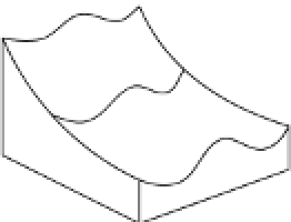
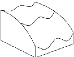
Figure 7.9
An explanation for the development of
ridge-and-valley topography in soil-mantled terrain.
Slope-dependent (diffusive) transport leads to convex
hillslopes, and when the topography is laterally perturbed
the transport direction (black lines) causes the topographic
highs to lower and topographic lows to fill in, resulting in
smooth topography, as suggested by the dashed line. In
contrast, advective transport, which depends on water flow
and slope gradient, carries sediment downslope and
produces concave hillslopes. Flow concentrations (black
flowpaths) resulting from lateral topographic perturbation
lead to incision, as suggested by the dashed lines. The
competition of these two processes leads to
diffusion-dominated ridges and advection-dominated
valleys.
Source:
Adapted from Dietrich and Perron (2006)
Box 7.2
THE UNIVERSAL SOIL LOSS EQUATION (USLE)
The USLE (Wischmeier and Smith 1978) predicts soil
loss from information about (1) the potential erosivity
of rainfall and (2) the erodibility of the soil surface.
The equation is usually written as:
E
=
R
×
K
×
L
×
S
×
C
×
P