Geology Reference
In-Depth Information
Hogback
Homoclinal ridge
Cuesta
Plateau
Butte
Dip
slope
Scarp
slope
Anti-dip
stream
Strike
stream
Dip
stream
Mesa
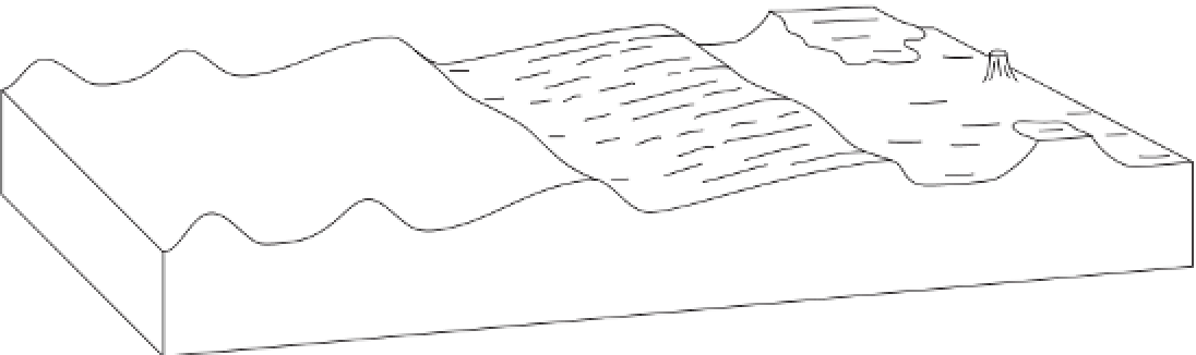
Figure 5.16
Landforms associated with dipping and horizontal strata - cuesta, homoclinal or strike ridge, hogback,
butte, mesa, and plateau. The chief streams found in landscapes with dipping strata - strike streams, anti-dip streams, and
dip streams - are shown. Notice that a cuesta consists of a dip slope and a steeper escarpment of scarp slope. The black
band represents a hard rock formation that caps the butte, mesa, and plateau.
including the Congo basin, Sudan basin, and Karoo
basin.
commonly develop along the strike.
Strike streams
gouge out strike valleys, which are separated by strike
ridges. Tributaries to the strike streams enter almost at
right angles. Those that run down the dip slope are
dip
streams
and those that run counter to the dip slope
are
anti-dip streams
. The length of dip and anti-dip
streams depends upon the angle of dip. Where dip is gen-
tle, dip streams are longer than anti-dip streams. Where
the dip is very steep, as in hogbacks, the dip streams and
anti-dip streams will be roughly the same length, but
often the drainage density is higher on the anti-dip slope
and the contours are more crenulated because the anti-
dip streams take advantage of joints in the hard stratum
while dip streams simply run over the surface.
Most stream networks are adapted to regional slope
and geological structures, picking out the main fractures
in the underlying rocks. The high degree of conformity
between stream networks and geological structure is evi-
dent in the nine chief drainage patterns (Morisawa 1985).
A tenth category,
irregular
or
complex drainage
, which
displays no unambiguous pattern, could be added - as
could an eleventh,
deranged drainage
, which forms
on newly exposed land, such as that exposed beneath
a retreating ice sheet, where there is almost no struc-
tural or bedrock control and drainage is characterized
Folds, rivers, and drainage patterns
Geomorphologists once described individual streams
according to their relationship with the initial sur-
face upon which they developed. A
consequent stream
flowed down, and was a consequence of, the slope of the
presumed original land surface. Streams that developed
subsequently along lines of weakness, such as soft strata
or faults running along the strike of the rocks, were
sub-
sequent streams
. Subsequent streams carved out new
valleys and created new slopes drained by
secondary
consequent
or
resequent streams
, which flowed in the
same direction as the consequent stream, and
obsequent
streams
, which flowed in the opposite direction. This
nomenclature is defunct, since it draws upon a presumed
time-sequence in the origin of different streams. In real-
ity, the entire land area drains from the start, and it is
patently not the case that some parts remain undrained
until main drainage channels have evolved. Modern
stream nomenclature rests upon structural control of
drainage development (Figure 5.16). In regions where a
sequence of strata of differing resistance is tilted, streams