Geography Reference
In-Depth Information
increasingly replaced by proprietary database storage formats. Although the
use of databases is expensive and usually requires specialized organization of
the GI and work, they are much quicker than the georelational model stor-
age. However, because of its additional complexity, the traditional georela-
tional model should remain a commonplace fixture of GIS for some time.
The georelational model relies on topology. Topology not only provides
a way to reduce the storage requirements for GI, it also provides a means to
speed up many processes and check for errors (see Chapter 7).
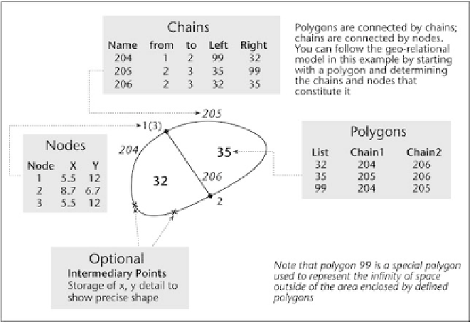
The georelational model consists of three main components connected
topologically. All three components are present and are linked to each
other. The first component is a table with a list of polygons (or areas). It
records the internal number of a polygon and the chains in the order that
make up the polygon's boundary. The second component is the table with a
list of chains (also called “lines” or “arcs”). Each chain entry consists of infor-
mation about the polygons to either side of the chain and the start and end
node of the chain. The start and end node define the direction of the chain
and which polygons are left and right. The third component of the
georelational model is a table of nodes. This table consists of the node identi-
fier and the
x
and
y
coordinates of each node.
Additions to the three components of the georelational model can be
made to improve the geographic representation and the cartographic repre-
sentation, especially the addition of additional points used to define the pre-
cise shape of a chain and indexes to speed up queries and the drawing time.
Raster GI representation relies on various types of encoding to reduce
the amount of storage required by a computer. If each raster or pixel cell is
Key components of the georelational model.


Search WWH ::

Custom Search