Geography Reference
In-Depth Information
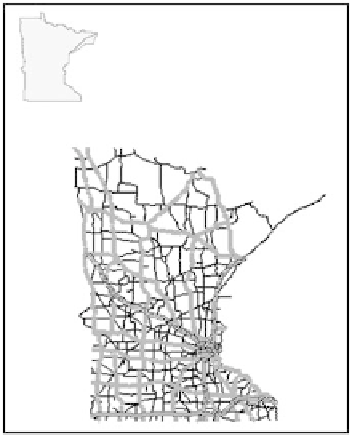
An example of an obvious error
resulting from using data sources for the same area
(Minnesota) but with different projections. Diagnosing
the causes of such errors and resolving them can be
very time-consuming if information about the projec-
tions is unavailable.
Summary
Projections have been the core of cartography and the basis for representing
geographic information. For millennia people have developed projections to
find ways to represent the three-dimensional world humans live on in two
dimensions—a format much better suited for recording observations and
measurements. While it is possible to make maps without a projection,
unprojected geographic information or maps are greatly inaccurate and dis-
torted. A projection can be applied to different areas and at different scales.
The smaller the area, the more accurate a projection can be. How accurate
the projection is depends on how the projection is constructed and what
underlying model of the earth's form it uses. Basic characteristics of a pro-
jection are its orientation, tangency, and form. Projections have several
properties. The most important properties are the preservation of angles
(conformality) or the preservation of areas (equivalent). Only one of these
two properties can be preserved in any one projection. Some projections dis-
tort both properties and are called compromise projections. The resulting
distortions can be ascertained and described using a Tissot indicatrix.
Because of the number of differences, it is important to assess the character-
istics and properties of projections when working with geographic informa-
tion, especially when combining geographic information from different
sources.


Search WWH ::

Custom Search