Environmental Engineering Reference
In-Depth Information
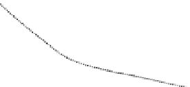
Virtual Hill
Steepness ~ 30%
120
Steepness ~ 40%
80
40
-100
100
0
Figure 16: Effect of a steep hill - fl ow separation [ 21 ] .
Table 4: Strengths and weaknesses of WAsP.
Strength
Weakness
Easy to use
Valid only for near-neutral conditions
Cheap and fast
Problems in complex terrain with fl ow
separation
Validated, limitations are known and
can be dealt with
Valid only for surface layer
One of the key simplifi cations of WAsP allowing this double extrapolation is the
linearisation of the Navier-Stokes equations. This simplifi cation is the main reason
for WAsP's limitation in complex terrain where the terrain slope exceeds 30° and
fl ow separation is likely to occur. Several studies have shown that WAsP tends to
make prediction errors in complex terrain [20]. Figure 16 shows that due to the
separation zones the stream lines follow the shape of a virtual hill with a somewhat
reduced steepness. However, WAsP uses the real hill steepness to calculate the
speed-up and is thus over-predicting the wind speed.
A correction of this model bias is possible using the so-called Ruggedness Index
(RIX) which is defi ned as the percentage of the area around an object that has
steepness above 30% (corresponds to 17° slope), thus the WAsP model assump-
tions are violated (Table 4). Figure 17 shows the relationship between expected
wind speed error and the difference in complexity between the position of the
measurement mast and the position of the future wind turbine. If the reference site
(measurement site) is less rugged and the predicted sites (WTGs) are very rugged,
the difference
RIX will be positive, and thus according to several studies an over-
prediction of the wind speed can be expected. If the reference site (measurement
site) is more rugged and the predicted sites (WTGs) are less rugged, the difference
Δ
Δ
RIX will be negative, and thus according to several studies an under-prediction
of the wind speed can be expected. The model bias will vary from site to site. It must
be emphasised that the
RIX description is a very much simplifi ed description of the
complexity variations in the terrain and that more data analysis is needed like that
shown in Fig. 17.
Δ


Search WWH ::

Custom Search