Environmental Engineering Reference
In-Depth Information
new boring is very close to the existing boring, the value increases as the distance increases,
and the value eventually reaches an asymptote once the spatial correlation between the new
boring and the existing boring becomes negligible. This asymptote is reached at the smallest
distance in the most heterogeneous geologic setting (i.e., “Marine/Alluvial” in
Figure 13.36
)
and at the largest distance in the most homogeneous geologic setting (i.e., “Marine” in
Figure 13.36
).
These results demonstrate how the value of information from site investiga-
tion data heavily depends on the geologic setting.
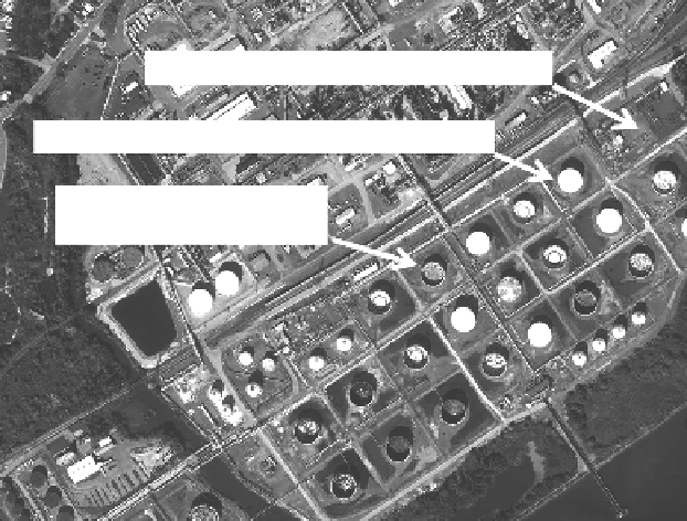
13.5.2 remedial investigation for a contaminated site
Figure 13.37
shows an oil refinery with potential contamination that may require remedia-
tion (see Gilbert 2002 for more details). One contaminant of concern was benzene in the
soil below storage tanks and processing facilities. Information was available about historical
land use and documented spills in various areas throughout the facility. In addition, several
investigations had been performed over the years to measure benzene concentrations in soil
samples.
The metric of interest in this analysis was the fraction of soil, H, with a benzene concen-
tration greater than the regulatory limit of 50 mg/kg. A prior probability distribution for
H was established based on historical land use and spill information. A β-distribution was
used to model H since it can be bounded between zero and one while taking on a variety of
shapes within the bounds and since it provides a mathematically convenient conjugate pair
for random sampling. Example distributions for the fraction of the contaminated samples
in different subareas are shown in
Figure 13.38
.
If there was no available information about
benzene contamination in a subarea, then a uniform distribution (one possible shape for
a β-distribution) was assumed. This prior β-distribution for H was then updated through
Bayes' Theorem with all available benzene concentration measurements for that subarea.
The sampling results were assumed to be independent within a subarea, meaning that the
likelihood function for the number of “hits” (i.e., samples with benzene concentrations
Area A - No hydrocarbon storage or processing
Area B - Hydrocarbon storage and documented spills
Area C - Hydrocarbon storage
and no documented spills
Figure 13.37
Oil refinery with potential need for remediation.
Search WWH ::

Custom Search