Travel Reference
In-Depth Information
Clay Bank Top is more correctly known as 'Hagg's Gate', and directly
opposite the point at which the path from Carr Ridge meets the B1257
Stokesley-Helmsley road, climb a flight of steps to gain a path rising be-
side a wall to a step-stile on the left, with a plantation on the right.
Note
A speedy and less demanding alternative route keeps right at this
point, along the edge of the plantation, bypassing Hasty Bank and the
Wainstones. It later cuts across the northern slopes of Cringle Moor, fol-
lowing a route taken by the jet and alum miners who worked this area, to
rejoin the main line of the walk just before reaching Lord Stones Café.
The main line crosses the step-stile to tackle the steep pull to Hasty
Bank. The entire route from Clay Bank onwards was paved during the
1990s, and makes for speedy progress and, more to the point, safer pro-
gress in poor visibility. Only the passage through the Wainstones isn't
paved, and this is obvious enough.
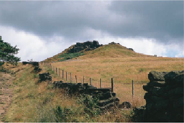
Once the ascent is complete, the path runs along the escarpment to
reach the top of the Wainstones, a tumble of boulders and rock walls
through which a number of paths thread a way. Below the Wainstones,
take the paved path bearing left, and this guides you down through lateral
walls into Garfit Gap, and up to a gate. More ascent leads on to Cold Moor,
followed by an easy descent to a gate. Follow the on-going wall round to
another gate at a wall corner. (The alternative low-level route arrives here
from the right, and the two routes rejoin briefly.)
Through the gate, go left to a signpost. (Here, the low-level route
branches right.) Go left and start climbing through mining spoil (Jet, page
149; Alum, page 149) to reach a splendid escarpment path around the
edge of Cringle Moor. The highest point of the moor, Drake Howe, lies off
to the left, marked by a pile of stones.
The Wainstones
Search WWH ::

Custom Search